Peru – much more than Machu Picchu
This article appears on page 6 of the September 2015 issue.
Peru lies in the tropics, south of the equator, and encompasses three distinctive geographic zones: the arid Pacific coast, the rugged Andes Mountains and part of the Amazon Basin. All the attention that its ancient Incan site of Machu Picchu received since being named one of the seven man-made wonders of the world is what put the country in the top tier on my “must see” list. However, once I arrived, I suddenly realized that there was so much more to this land of sharp contrasts.
Making plans
For several years I had been corresponding with Manuel Arboleda, an anthropologist in Lima who conducts an annual tour for his company, Nawpaq Expeditions (Lima, Peru; phone +511 65 432 65, www.nawpaqexpeditions.com). The ad in ITN for this cultural expedition, “Coca, Kings and Monkeys,” caught my eye, as it sounded as though the tour offered a more personal view of Manuel’s native country.
Our schedules finally coincided in 2014, so my wife, Pat, and I signed up for the May 7-21 tour. The land-only price was $2,700 per person, with an additional $450 each for the three flights within Peru. This price included 14 breakfasts, 10 lunches and 2 dinners.
Whenever we travel, Pat and I like to arrive at our starting point a day before the beginning of any organized activity and leave a day after, if we can. On this trip, we were able to schedule two extra days in Peru.
Our United Airlines routing was from San Francisco to Lima via Houston. Our flight, like most international flights into the capital, landed in Lima after dark. Though it was past 10 p.m., there was a warm, moist feel to the air outside as we walked from the terminal to our waiting cab.
The ride from the airport to the Miraflores area, where we were staying, took us down from the bluffs of Lima along the Pacific Ocean.
Though Lima is only 12 degrees south of the equator, the temperature felt very mild. We learned later that this is the result of fog condensation caused by the Humboldt Current bringing cold water up the west coast of South America from the Antarctic. When combined with the strong tropical sun, it creates a misty fog called garua during the winter months of May to August.
Lima
On our first day on our own, we did a lot of walking around the Miraflores area, from Parque Central through Parque Kennedy and on to El Parque del Amor, overlooking the Pacific from the bluffs.
We continued along the Malecón (the seawall and waterfont promenade) to Larcomar, a modern shopping center comprised of many high-end shops and restaurants built out over the cliffs. The views from some of the shops gave the feeling of being suspended in space.
That evening we scheduled a guided tour through Viator (www.viator.com) for $79 per person, including a gourmet dinner of Peruvian dishes at the Museo Larco (Av. Bolivar 1515). The museum had been highly recommended for its very large collection of pre-Columbian jewelry and artifacts spanning more than 5,000 years.
A large part of the museum is housed in the beautifully restored former home of a Peruvian sugar baron. At times, we were the only people in some of the galleries and the only ones to tour the glass-enclosed storage rooms. (It could have been the late hour.)
To top it off, the dinner in the on-site restaurant was excellent. We felt that the entire package provided a great overview of the culture and history of Peru and gave us a good start for our upcoming expedition.
The tour begins
The first day of our adventure began with a gathering of our tour group of 20 to meet Manuel. Our survey of Lima started at the ruins of a pre-Inca pyramid located right in the middle of this vast city. Huaca Pucllana is a 75-foot-high adobe-brick pyramid and ceremonial center that dates from AD 200 to 700. It seemed so out of place in the midst of the bustling city, but it is of great historic significance.
From there we went on to explore monumental Lima, the historical center of Spanish South America.
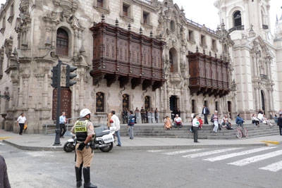
The colonial center of the city is the Plaza Mayor. We saw its impressive Palace of the Archbishop, with fine carved balconies; the Government Palace, which includes the official residence of the president, and the 16th-century Cathedral of Lima, whose first stone was laid by Francisco Pizarro, who founded the city in 1535.
A short stroll down a side street took us to Casa de Aliaga, built in 1535 and home to 17 generations of the Aliaga family.
Lunch on our first tour day in Lima was at the stunning La Rosa Nautica Restaurante, built out on a pier over the ocean. It was a unique setting in which to sample some of the fresh local seafood, including the world-famous Peruvian ceviche.
There was free time that afternoon for more exploring around the Miraflores area, with a highlight being the piano playing in Parque Central. This always seemed to attract a crowd, including some of the local cats.
That evening our group had a chance to participate in a Nawpaq Expeditions special: a welcome cocktail at Manuel’s mother’s house. His mother is 92 years old and seemed to enjoy every minute of the snacks, drinks and conversation. What a charming way to get to know the other members of our group and share in some local hospitality.
Contrasting landscapes
The next day we boarded our bus early and left Lima to explore the desert of the Paracas National Reserve. On the way, we stopped for lunch in the coastal community of Pisco. As the town has been made famous by the local grape that is made into the brandy used in the country’s signature drink, the Pisco sour, we felt compelled to wash down our beautiful seafood lunch with a taste of the national drink.
The desert, located a few miles south of Pisco, is one of the most arid places on Earth. This phenomenon is caused by a combination of any moisture moving west along the equator being blocked by the Andes, less than a hundred miles to the east, plus the upwelling of the cold Humboldt Current just offshore.
The desert meets the sea in a dramatic fashion, with multicolored sand dunes giving way to impressive cliffs that plunge into the Pacific. Though there was no sea life in sight, the occasional fossil bed served as evidence that at one time, several million years ago, this was an ocean bottom.
Day three started out early as we boarded boats for the half-hour ride out to the Ballestas Islands, a small group of volcanic cones containing arches and caves that provide shelter for more than 160 species of birds as well as a sizable seal population. Where the mainland just to the east was void of life, the islands swarmed with a population that must have numbered in the hundreds of thousands — all there to feed on the nutrient-rich waters. It was a constant feeding frenzy and a bird-watcher’s paradise.
Visitors are not allowed to disembark on the islands, so we were given an extensive tour around the islands from the water. We must have seen just about all of the 100-plus bird species, including the Humboldt penguins. It was hard to believe that we were spotting flocks of penguins so close to the equator.
Into the jungle
We had a 4-hour bus ride back to our hotel in Lima, where we had to prepare for a very early morning departure. We were scheduled on a “break of dawn” flight to Puerto Maldonado and the Amazon Basin. This is where we would catch up with the “monkey” portion of Manuel’s expedition in the jungle.
Traveling into the rainforest, we took a 45-minute boat ride down the Madre de Dios River to the Inkaterra Reserva Amazónica Lodge. At that point, the river is a half-mile wide, and we were only about 100 miles from the headwaters in the Andes.
The lodge was another of the many surprises on this expedition. It is a luxury accommodation made up of a group of thatch-roofed cottages with canopy beds, hammocks and balconies overlooking the lush tropical jungle.
A 5-star resort set in the middle of the rainforest, it featured three meals a day, including candlelit gourmet dinners. Informative nature talks, hikes through the local ecosystem, boat tours to surrounding areas and a canopy tour on walkways connected by 90-foot-high towers offering a view of the abundant life above the trees further enhanced our stay.
Our two days in the Amazon Basin ended way too quickly, but we did get to see a vast diversity of plants and animals in this short period of time. (And, yes, we saw monkeys.)
Cusco and coca
Day six began with a boat trip back up the river to Puerto Maldonado to catch a 45-minute flight to Cusco. This is where we would learn the reason for the inclusion of “coca” in the title of the Nawpaq tour.
Walking from the plane to the luggage-claim area, we saw several stands with large teapots filled with hot water and bags or boxes of coca leaves. For about a dollar you could get a cup of hot water and a handful of the leaves to make your own cup of mate de coca, as the locals call it. It makes a soothing potion that visitors can use to help get acclimatized to the 11,000-foot altitude of Cusco.
In the airport, they also sell cans of oxygen, called “oxishots,” each of which comes with its own mask to deliver a burst of oxygen when you are short of breath. We bought one ($15) and found it useful later on the trip. It was only used a few times when we got winded walking up hills, but the reassurance of knowing it was available made it a smart purchase, for us.
We headed down to the lower elevations of the Urubamba Valley (aka the Sacred Valley of the Incas), which allowed us to get acclimated more gradually to the altitude. We stopped in Pisac for lunch and a visit to the famous market there.
Then it was on to the town of Urubamba, where we spent two nights at a converted monastery called San Agustín Monasterio de la Recoleta, situated at an altitude of 9,000 feet.
Heading up
The next day we headed farther up the valley and got a better appreciation for how the Incas utilized almost every conceivable parcel of this fertile basin for agricultural purposes. It takes some time traveling through this area to appreciate the scope and extent of their empire.
Our first stop was in the town of Ollantaytambo, with its imposing ruins overlooking the valley. The Incan stone masonry there is some of the most impressive in the area.
It is said to be the best preserved of all the Incan settlements. The old walls of the houses are still standing, and the structures have been subdivided and are now occupied by local families. Water still runs through the 15th-century channels in the narrow streets.
After our tour of the ruins and a brief stop at the town market, we boarded our bus for an hour’s drive on a one-lane road up into the mountains outside of Ollantaytambo. We were headed to the Quechua-speaking community of Patacancha, where the townsfolk had prepared a pachamanca for our group.
This traditional Peruvian feast is cooked with hot stones in a covered earthen oven. The dishes included a wide variety of meats and vegetables, with at least six different versions of the more-than-2,000 varieties of potatoes available in Peru.
Machu Picchu
Day nine brought another early start, as we were scheduled to catch PeruRail’s 8 a.m. Vistadome train from Ollantaytambo to Aguas Calientes. The 1½-hour ride meandered through ravines, gorges and tunnels, following the course of the Urubamba River to the base of Machu Picchu. We checked our luggage into our hotel and caught the bus for the 30-minute ride up the switchbacks to Machu Picchu.
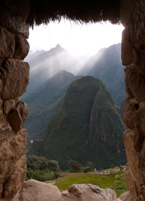
Located at an altitude of 8,000 feet above sea level in a cloud forest surrounded by the snow-covered peaks of the Vilcabamba Range, Machu Pichhu was built around 1460. The site is comprised of approximately 200 buildings, all exhibiting the key Incan architectural design components of being simple, symmetrical and solid.
Over the next three days, we returned to Cusco and spent time exploring in and around the former capital city of the Inca Empire.
There was time on the first afternoon for a walk around the Plaza de Armas, which has been a significant ceremonial place throughout the city’s history.
Also within an easy stroll from our hotel were several streets lined by the ancient walls of the Incas. The builders were masters of stone cutting, and these massive walls were constructed with such geometric precision that mortar was not needed to hold the stones in place.
Lake Titicaca
The day-long drive from Cusco to Puno and Lake Titicaca was highlighted by beautiful vistas of the Andean Altiplano, the “roof of South America.” Our first stop was in the village of Andahuaylillas to visit its late-16th-century church, nicknamed the Sistine Chapel of the Americas. The simple façade offered no hint of the lavish collections of frescoes and gold leaf contained within.
We eventually came to La Raya Pass. At 14,172 feet, it was the highest point on the drive and provided some beautiful views of the surrounding snowcapped mountains. We visited some of the cluster of handicrafts sellers who had gathered at this tourist stop.
Farther along the route we passed fields of Peruvian camelids — llamas, alpacas and vicuñas. For more than 6,000 years these animals have served as a source of food and clothing and as beasts of burden. Each of the species has an important place in the culture of the country.
The llama is the largest and the strongest and is used mainly as a pack animal. The alpaca is used for the fiber it produces and also as a food source. The vicuña, the smallest, produces an extremely fine wool that is in high demand and very expensive. This animal runs wild and is protected by law.
We finally reached the town of Puno, where we spent the last two nights of our expedition. Puno is located on the western shores of Lake Titicaca, which, at 12,500 feet, is the world’s highest navigable lake.
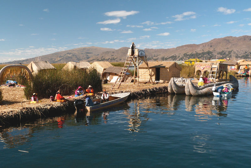
The main reason for visiting Puno is that it is the stepping-off point for visiting the lake’s surprising floating “islands,” made from totora reeds.
The totora reeds that grow in the shallows of the lake float because of their hollow structure. The islands are constructed from many layers of dried totora, which are constantly being replenished from the top as they rot from below, so the “ground” is always soft and spongy.
Our group took a boat to the best known of these islands, the Islas de los Uros, named after the natives who inhabit them. Then we continued our tour of Lake Titicaca with a visit to Isla Taquile, a large island noted for its well-made woolen and alpaca goods.
A stairway of more than 500 steps led from the dock to the top of the center of the island, where the farewell lunch of the Nawpaq expedition was held. The climb and the return descent at the 12,000-foot altitude made for a very active last day.
Winding down
Since our group’s flight back to Lima did not leave until the afternoon and we had to drive to the town of Juliaca to catch the plane, we made two more stops before our tour officially came to an end.
The first was Sillustani to visit an ancient burial site of circular towers apparently used for members of the nobility, who were entombed with the remains of their entire families and their possessions to take them to the next world. The towers date back to the 12th century, predating the Inca civilization in the area.
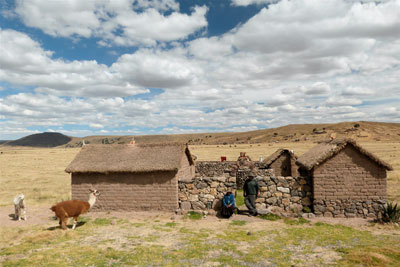
The area between Puno and Juliaca is populated by Aymara-speaking people, and our last highlight was a stop to visit a local homestead. The family had a small house and some llamas and did some weaving to generate extra income. They were very gracious and welcoming.
Fortunately, Manuel speaks the Aymara language, so we were able to get our many questions answered and learn more about their culture and lifestyle.
So there it is. I’ve chronicled the daily activities of my Nawpaq tour, but the most memorable part was gaining a deeper understanding of the culture, politics and history of Peru from our knowledgeable guide, Manuel Arboleda.
His affection for his native country was evident, yet he shared a realistic viewpoint as he addressed the challenges and successes of Peru, a country that is just now emerging from its tumultuous past and gaining traction as it moves into the 21st century.


